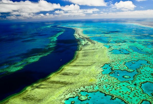
The Great Barrier Reef is the world's largest coral reef system composed of over 2,900 individual reefs and 900 islands stretching for over 2,300 kilometres (1,400 mi) over an area of approximately 344,400 square kilometres (133,000 sq mi). The reef is located in the Coral Sea, off the coast of Queensland, Australia.
The Great Barrier Reef can be seen from outer space and is the world's biggest single structure made by living organisms. This reef structure is composed of and built by billions of tiny organisms, known as coral polyps. It supports a wide diversity of life and was selected as a World Heritage Site in 1981. CNN labeled it one of the seven natural wonders of the world. The Queensland National Trust named it a state icon of Queensland.
A large part of the reef is protected by the Great Barrier Reef Marine Park, which helps to limit the impact of human use, such as fishing and tourism. Other environmental pressures on the reef and its ecosystem include runoff, climate change accompanied by mass coral bleaching, and cyclic population outbreaks of the crown-of-thorns starfish. According to a study published in October 2012 by the Proceedings of the National Academy of Sciences, the reef has lost more than half its coral cover since 1985.
The Great Barrier Reef has long been known to and used by the Aboriginal Australian and Torres Strait Islander peoples, and is an important part of local groups' cultures and spirituality. The reef is a very popular destination for tourists, especially in the Whitsunday Islands and Cairns regions. Tourism is an important economic activity for the region, generating over $3 billion per year.
In November 2014, Google launched Google Underwater Street View in 3D of the Great Barrier Reef.
The Great Barrier Reef is a distinct feature of the East Australian Cordillera division. It includes the smaller Murray Islands. It reaches from Torres Strait (between Bramble Cay, its northernmost island, and the south coast of Papua New Guinea) in the north to the unnamed passage between Lady Elliot Island (its southernmost island) and Fraser Island in the south. Lady Elliot Island is located 1,915 km (1,190 mi) southeast of Bramble Cay as the crow flies.
The Plate tectonic theory indicates Australia has moved northwards at a rate of 7 cm (2.8 in) per year, starting during the Cenozoic. Eastern Australia experienced a period of tectonic uplift, which moved the drainage divide in Queensland 400 km (250 mi) inland. Also during this time, Queensland experienced volcanic eruptions leading to central and shield volcanoes and basalt flows. Some of these became high islands. After the Coral Sea Basin formed, coral reefs began to grow in the Basin, but until about 25 million years ago, northern Queensland was still in temperate waters south of the tropics—too cool to support coral growth. The Great Barrier Reef's development history is complex; after Queensland drifted into tropical waters, it was largely influenced by reef growth and decline as sea level changed.
Reefs can increase in diameter by 1 to 3 centimetres (0.39 to 1.18 in) per year, and grow vertically anywhere from 1 to 25 cm (0.39 to 9.84 in) per year; however, they grow only above a depth of 150 metres (490 ft) due to their need for sunlight, and cannot grow above sea level. When Queensland edged into tropical waters 24 million years ago, some coral grew, but a sedimentation regime quickly developed with erosion of the Great Dividing Range; creating river deltas, oozes and turbidites, unsuitable conditions for coral growth. 10 million years ago, the sea level significantly lowered, which further enabled sedimentation. The reef's substrate may have needed to build up from the sediment until its edge was too far away for suspended sediments to inhibit coral growth. In addition, approximately 400,000 years ago there was a particularly warm interglacial period with higher sea levels and a 4 °C (7 °F) water temperature change.
The land that formed the substrate of the current Great Barrier Reef was a coastal plain formed from the eroded sediments of the Great Dividing Range with some larger hills (some of which were themselves remnants of older reefs or volcanoes). The Reef Research Centre, a Cooperative Research Centre, has found coral 'skeleton' deposits that date back half a million years. The Great Barrier Reef Marine Park Authority (GBRMPA) considers the earliest evidence of complete reef structures to have been 600,000 years ago. According to the GBRMPA, the current, living reef structure is believed to have begun growing on the older platform about 20,000 years ago. The Australian Institute of Marine Science agrees, placing the beginning of the growth of the current reef at the time of the Last Glacial Maximum. At around that time, sea level was 120 metres (390 ft) lower than it is today.
From 20,000 years ago until 6,000 years ago, sea level rose steadily around the world. As it rose, the corals could then grow higher on the newly submerged maritime margins of the hills of the coastal plain. By around 13,000 years ago the sea level was only 60 metres (200 ft) lower than the present day, and corals began to surround the hills of the coastal plain, which were, by then, continental islands. As the sea level rose further still, most of the continental islands were submerged. The corals could then overgrow the submerged hills, to form the present cays and reefs. Sea level here has not risen significantly in the last 6,000 years. The CRC Reef Research Centre estimates the age of the present, living reef structure at 6,000 to 8,000 years old.
The remains of an ancient barrier reef similar to the Great Barrier Reef can be found in The Kimberley, Western Australia.
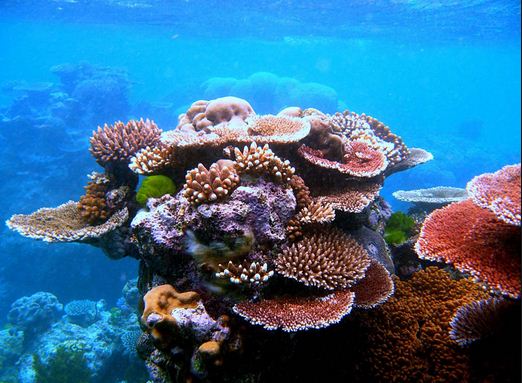
The Great Barrier Reef World Heritage Area has been divided into 70 bioregions, of which 30 are reef bioregions. In the northern part of the Great Barrier Reef, ribbon reefs and deltaic reefs have formed; these structures are not found in the rest of the reef system. There are no atolls in the system, and reefs attached to the mainland are rare.
Fringing reefs are distributed widely, but are most common towards the southern part of the Great Barrier Reef, attached to high islands, for example, the Whitsunday Islands. Lagoonal reefs are found in the southern Great Barrier Reef, and further north, off the coast of Princess Charlotte Bay. Cresentic reefs are the most common shape of reef in the middle of the system, for example the reefs surrounding Lizard Island. Cresentic reefs are also found in the far north of the Great Barrier Reef Marine Park, and in the Swain Reefs (20–22 degrees south). Planar reefs are found in the northern and southern parts, near Cape York Peninsula, Princess Charlotte Bay, and Cairns. Most of the islands on the reef are found on planar reefs.
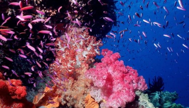
The Great Barrier Reef supports a diversity of life, including many vulnerable or endangered species, some of which may be endemic to the reef system.
Thirty species of whales, dolphins, and porpoises have been recorded in the Great Barrier Reef, including the dwarf minke whale, Indo-Pacific humpback dolphin, and the humpback whale. Large populations of dugongs live there. More than 1,500 fish species live on the reef, including the clownfish, red bass, red-throat emperor, and several species of snapper and coral trout. Forty-nine species mass spawn, while eighty-four other species spawn elsewhere in their range. Seventeen species of sea snake live on the Great Barrier Reef in warm waters up to 50 metres (160 ft) deep and are more common in the southern than in the northern section. None found in the Great Barrier Reef World Heritage Area are endemic, nor are any endangered.
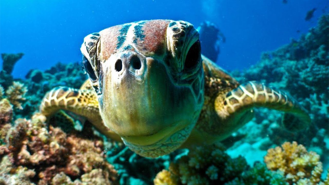
Six species of sea turtles come to the reef to breed: the green sea turtle, leatherback sea turtle, hawksbill turtle, loggerhead sea turtle, flatback turtle, and the olive ridley. The green sea turtles on the Great Barrier Reef have two genetically distinct populations, one in the northern part of the reef and the other in the southern part. Fifteen species of seagrass in beds attract the dugongs and turtles, and provide fish habitat. The most common genera of seagrasses are Halophila and Halodule.
Saltwater crocodiles live in mangrove and salt marshes on the coast near the reef. Nesting has not been reported, and the salt water crocodile population in the GBRWHA is wide-ranging but low density. Around 125 species of shark, stingray, skates or chimaera live on the reef. Close to 5,000 species of mollusc have been recorded on the reef, including the giant clam and various nudibranchs and cone snails. Forty-nine species of pipefish and nine species of seahorse have been recorded. At least seven species of frog inhabit the islands.
215 species of birds (including 22 species of seabirds and 32 species of shorebirds) visit the reef or nest or roost on the islands, including the white-bellied sea eagle and roseate tern. Most nesting sites are on islands in the northern and southern regions of the Great Barrier Reef, with 1.4 to 1.7 million birds using the sites to breed. The islands of the Great Barrier Reef also support 2,195 known plant species; three of these are endemic. The northern islands have 300–350 plant species which tend to be woody, whereas the southern islands have 200 which tend to be herbaceous; the Whitsunday region is the most diverse, supporting 1,141 species. The plants are propagated by birds.
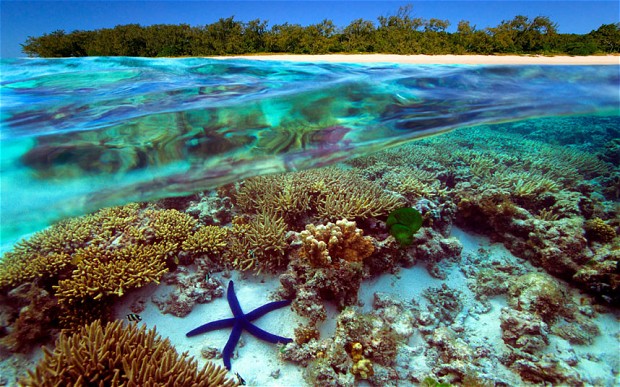
There are at least 330 species of ascidians on the reef system with the diameter of 1–10 cm (0.4–4 in). Between 300–500 species of bryozoans live on the reef. Four hundred coral species, both hard corals and soft corals inhabit the reef. The majority of these spawn gametes, breeding in mass spawning events that are triggered by the rising sea temperatures of spring and summer, the lunar cycle, and the diurnal cycle. Reefs in the inner Great Barrier Reef spawn during the week after the full moon in October, while the outer reefs spawn in November and December. Its common soft corals belong to 36 genera. Five hundred species of marine algae or seaweed live on the reef, including thirteen species of genus Halimeda, which deposit calcareous mounds up to 100 metres (110 yd) wide, creating mini-ecosystems on their surface which have been compared to rainforest cover.
The Great Barrier Reef has long been known to and used by the Aboriginal Australian and Torres Strait Islander peoples. Aboriginal Australians have been living in the area for at least 40,000 years, and Torres Strait Islanders since about 10,000 years ago. For these 70 or so clan groups, the reef is also an important cultural feature.
In 1768 Louis de Bougainville found the reef during an exploratory mission, but did not claim the area for the French. On 11 June 1770, the HM Bark Endeavour, captained by explorer James Cook, ran aground on the Great Barrier Reef, sustaining considerable damage. Lightening the ship and re-floating it during an incoming tide eventually saved it. One of the most famous wrecks was the HMS Pandora, which sank on 29 August 1791, killing 35 men. The Queensland Museum has led archaeological digs to the Pandora since 1983. Because the reef had no atolls, it was largely unstudied in the 19th century. During this time, some of the reef's islands were mined for deposits of guano, and lighthouses were built as beacons throughout the system. as in Raine Island, the earliest example. In 1922, the Great Barrier Reef Committee began carrying out much of the early research on the reef.
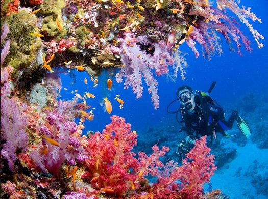
Due to its vast biodiversity, warm clear waters and accessibility from the tourist boats called "live aboards", the reef is a very popular destination, especially for scuba divers. Tourism on the Great Barrier Reef is concentrated in Cairns and also The Whitsundays due to their accessibility. These areas make up 7%-8% of the Park's area. The Whitsundays and Cairns have their own Plans of Management. Many cities along the Queensland coast offer daily boat trips. Several continental and coral cay islands are now resorts, including the pristine Lady Elliot Island. As of 1996, 27 islands on the Great Barrier Reef supported resorts.
In 1996, most of the tourism in the region was domestically generated and the most popular visiting times were during the Australian winter. At this time, it was estimated that tourists to the Great Barrier Reef contributed A$776 million per annum. As the largest commercial activity in the region, it was estimated in 2003 that tourism generated over A$4 billion annually, and the 2005 estimate increased to A$5.1 billion. A Deloitte report published by the Great Barrier Reef Marine Park Authority in March 2013 states that the Reef's 2,000 kilometres of coastline attracts tourism worth A$6.4 billion annually and employs more than 64,000 people.
Approximately two million people visit the Great Barrier Reef each year. Although most of these visits are managed in partnership with the marine tourism industry, there is a concern among the general public that tourism is harmful to the Great Barrier Reef.
A variety of boat tours and cruises are offered, from single day trips, to longer voyages. Boat sizes range from dinghies to superyachts. Glass-bottomed boats and underwater observatories are also popular, as are helicopter flights. By far, the most popular tourist activities on the Great Barrier Reef are snorkelling and diving, for which pontoons are often used, and the area is often enclosed by nets. The outer part of the Great Barrier Reef is favoured for such activities, due to water quality.
Management of tourism in the Great Barrier Reef is geared towards making tourism ecologically sustainable. A daily fee is levied that goes towards research of the Great Barrier Reef. This fee ends up being 20% of the GBRMPA's income. Policies on cruise ships, bareboat charters, and anchorages limit the traffic on the Great Barrier Reef.
The problems that surround ecotourism in the Great Barrier Reef revolve around permanent tourism platforms. Platforms are large, ship-like vessels that act as a base for tourists while scuba diving and snorkeling in the Great Barrier Reef. Seabirds will land on the platforms and defecate which will eventually be washed into the sea. The feces carry nitrogen, phosphorus and often DDT and mercury, which cause aspergillosis, yellow-band disease, and black band disease. Areas without tourism platforms have 14 out of 9,468 (1.1%) diseased corals versus areas with tourism platforms that have 172 out of 7,043 (12%) diseased corals. Tourism is a major economic activity for the region. Thus, while non-permanent platforms could be possible in some areas, overall, permanent platforms are likely a necessity. Solutions have been suggested to siphon bird waste into gutters connecting to tanks helping lower runoff that causes coral disease.
The Great Barrier Reef Marine Park Authority has also placed many permanent anchorage points around the general use areas. These act to reduce damage to the reef due to anchoring destroying soft coral, chipping hard coral, and disturbing sediment as it is dragged across the bottom. Tourism operators also must comply with speed limits when travelling to or from tourist destinations, in order to prevent excessive wake from the boats disturbing the reef ecosystem.