Over the past decade the appellation Kazakl'i-yatkan has become the most commonly used name for this site in both the archaeological literature and the popular media. Kazakl'i-yatkan is an English transliteration of Казаклы-яткан, the simplified Russian form of its local Karakalpak name - Қазақлы-яткан in Cyrillic or Qazaqlı-yatqan in Latin. The literal meaning of the name is "Qazaqs are lying down". The term dates from the early 1930's when the area was occupied by exhausted Qazaqs who had fled south from the chaos and starvation engulfing western Kazakhstan following Stalin's enforced collectivization.
Prior to this time the site was known by the local Karakalpaks as Ақша Хан Қала or Axsha Xan Qala, transliterated to Akcha Khan Kala or Akhcha Khan Kala from the Russian. The name is derived from a legendary leader of the same name.
Kazakl'i-yatkan is just over 15km north of Biruniy city centre and 13km south of the escarpment of the Sultan Uvays Dag.
It lies in the north-western part of what archaeologists now call the Tash-k'irman oasis, a former agricultural region that was once watered by a northern arm of the Akcha Darya. This outlet of the Amu Darya seems to have finally ceased its natural flow in the early centuries of the 1st millennium. All that remains today is an extensive region of sandy desert and lakes known as the Aq Qum Sands, which extends for about 30km in a north-easterly direction starting from the south-east of Biruniy. The most northern part of this strip of desert is known as the Daganıoldı Sands, and this is the location of Kazakl'i-yatkan (Axsha Xan Qala). The sands, which come from the ancient bed of the Akcha Darya, have not only concealed the site but have preserved it for posterity. The largest lake in the region, which forms the northern boundary to the Aq Qum Sands, is still known as Akcha Ko'l.
Although the site is still being actively investigated, visitors are welcome but are requested to contact the site caretaker on arrival. The main annual excavation season is from September to early October. Beware that some of the excavations from previous seasons have been reburied to protect the monument from erosion.
It takes just under two hours to reach the site from Khiva. First drive through Urgench and cross the Amu Darya pontoon bridge linking the viloyat of Khorezm with Karakalpakstan. From the north bank check-point drive north for 2km and then cross the To'rtku'l road. Continue north for a further 1.6km and turn left onto the main highway for just 0.3km before turning right and continuing for a further 0.2km to the crossroad.
Turn left. From this point the road immediately bends to the right taking you in a northerly direction. After 1.4km you cross the main road and after 10.8km you take a left turn. The road, which has houses on both sides, continues west for 2.9km before bending to the north. From now on measure your distances from this bend. Some 3.4km beyond the bend the landscape on the left of the road turns into desert. At 5.8km from the bend there is a right fork which after 300 metres leads to the entrance to the site of Kazakl'i-yatkan on the right hand side. There are two buildings on either side of the entrance, the caretaker's house on the right and the archaeologists' dormitory on the left. After reporting to the caretaker you can walk south across the desert to reach the partially buried site.
Alternatively you can reach the site from No'kis. It is only 115km as the crow flies but it takes 136km or about two hours by road. Leave No'kis on the A380 highway to Biruniy. After 93km from No'kis the road passes the turn to the Badai Tugai Reserve on the right and after 109km it bends to the right and then heads south from the mountains towards Biruniy. Just after Kalenderkhana, some 6½km from the last bend and 116km from No'kis, take the left turn. In less than 10km this side road reaches a t-junction. Turn right. After a further 9½km there is a small left turn, just as the landscape turns to desert. The entrance to Kazakl'i-yatkan is just 300 metres on the left.
The Tash-k'irman oasis was first discovered and investigated by a detachment of the Khorezm Archaeological Expedition led by Boris Vasilyevich Andrianov in 1956. Following its identification, Kazakl'i-yatkan was surveyed the same year using aerial photography. Andrianov's main discovery at this time was an sizeable ancient canal, some 17 metres wide from bank to bank, along with its associated irrigation network, agricultural settlements and field systems. The canal was then thought to date from at least the 4th century BC and continued to be used up to the 8th century AD.
The first explorations of Kazakl'i-yatkan took place as part of a survey prompted by the planned construction of the new railway line to the east of the Tash-k'irman oasis. Kazakl'i-yatkan was surveyed and superficially examined in both 1982 and 1985 by G'ayratdiyin Xojaniyazov and his colleagues from the Department of Archaeology at the Karakalpak Branch of the Academy of Sciences of the Uzbek SSR in No'kis. The team also discovered another archaeological site 6km to the south-east of Kazakl'i-yatkan, which they named Tash-k'irman tepe.
In 1992 discussions had commenced about the possibility of future collaboration between Professor Vadim Yagodin and his archaeologists at the Institute of History, Archaeology and Ethnography in No'kis and Dr Alison Betts (now Associate Professor) and her colleagues in the Department of Archaeology at the University of Sydney. The outcome was the formation in 1995 of the Karakalpak-Australian Archaeological Expedition, tasked with the ambitious objective of continuing the earlier archaeological work of Professor Sergey Tolstov and his Khorezm Archaeological-Ethnographical Expedition.
Professor Yagodin had been intrigued by the possible existence of a so far undiscovered ancient capital city. The Persian postmaster Ibn Khordadbeg, writing around 850, made a brief comment that the capital city of Khorezm had been moved to nearby Kath after an earlier city named Dargash or Darjash had been flooded. Previous archaeologists such as Yuri Rapoport, who masterminded the excavation of Topraq qala, assumed that Dargash - if it had ever existed - must have been close to the present Amu Darya. However flooding does not necessarily imply total destruction. One possible candidate for the lost city was the 32-hectare site of Bazar Qala, 32km north-west of To'rtku'l. However the larger 47-hectare site of Kazakl'i-yatkan, coupled with the nearby ruins of Tash-k'irman, looked more promising and had the added attraction that they both remained virtually undisturbed. Both were close to a region that had been flooded by an ancient body of water known as the Istemes Lake, mentioned by some 10th century writers.
The first season of work at Kazakl'i-yatkan began in September 1995 and has continued annually ever since. The work was initially directed by Vadim Yagodin and Sven Helms, with assistance from G'ayratdiyin Xojaniyazov and N. Yusopov. The first major excavations in 1996 involved cutting long trenches across the walls of both the inner and the outer enclosures to deduce the history of their structure and design, as well as an investigation of a centrally located monument in the upper enclosure. Between 1997 and 2000 work concentrated on the fortifications of the eastern wall of the upper enclosure. A structure in the north-west corner of the upper enclosure, thought to be a palace or temple, was first explored in 2000 identifying fragments of a stucco frieze decorated with gold leaf. When excavations in 2001 uncovered fragments of painted plaster, the absence of a conservator forced work to a halt.
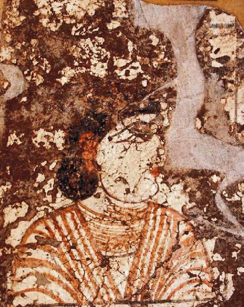
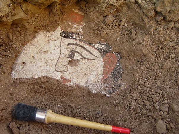
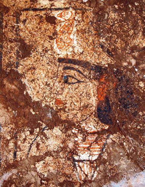
From 2002 onwards work has concentrated on exploring the detailed layout of the temple-palace, resulting in the discovery and conservation of a large number of polychrome wall murals. The highlight so far has been the discovery in 2006 of a series of portraits. It is not clear whether these represent real personages such as members of the ruling dynasty or legendary or mythical characters. It is clear that the site was an important royal and/or religious centre, which may well have been the capital city of an independent Khorezm and the residence of its ruling Khorezmshahs. Whether it was Ibn Khordadbeg's city of Dargash is impossible to say with certainty.